How Geophysical Methods Improve Dam Safety and Early Risk Detection
Dams are barriers that stop or restrict the flow of liquid. They have been used for 1000’s of years with the main purpose of storing water. As civilization and technology developed dams evolved to also being used for other purposes such as generating electricity, suppressing floods, storing waste, for navigational purposes or as part of mining operations. Worldwide, there are approximately 60 000 registered large dams, and the top three uses are irrigation, hydropower and water supply.
Often the dam has a complex engineered structure and represents not only a major investment for the owner but also offers huge benefits for a lot of people. As dams grow older, monitoring the state of the dam and performing maintenance, where needed, is of utmost importance to keep these benefits. In some instances, dams may be so old that they were built long before legislation was in place regarding design and construction practices or were built as temporary structures but are now still required long beyond their intended lifespan.
In the event of a dam failure, the economic loss as well as the potential hazard to life and property could be enormous. Typical dam safety surveillance consists of visual inspections supported by limited geotechnical tests. A major disadvantage with this approach is that problems can become severe before being detected, thus increasing the risk of failure and the cost for repairs.
Geophysical methods offer non-intrusive techniques to assist early detection of anomalous zones that can be precursors to dam failure. As dam designs vary greatly, and often consist of different types of materials within a single structure, there is not one geophysical method that can be used in all situations or will resolve all problems. In many cases a solution utilizing multiple geophysical techniques is required to get a full overview of the dam condition.
Different Methods for Dam Investigations
Guideline Geo´s wide range of different geophysical investigation techniques solves most of the common questions regarding dam safety investigations, for different types of dam construction. They will give a non-destructive and cost-efficient way of investigating the sub-surface conditions, where greater data coverage is normally achieved compared to point-wise traditional geotechnical investigations such as drilling or digging.
In Table 1 the most common applications for dam safety and the geophysical solutions of Guideline Geo are listed. All solutions will provide output as an image of the physical parameter measured and/or as a file of position (XY) and depth (Z) to features of interest, such as layers, objects, anomalous zones, which is easily transferred to GIS or CAD software packages.

Ground Penetrating Radar for Dam Safety Investigations
The use of Ground Penetrating Radar (GPR) for dam safety investigation is suitable for:
- Mapping cracks and areas of degradation in concrete dams
- Positioning of rebars in concrete dams. Read more: Application Area Concrete Construction and Rebars
- Mapping of water leaks, landslide areas and sinkholes in embankment dams
- Mapping water leaks in masonry dams.
- Estimating volumes of sedimentation in the dam reservoirs

The amount of sedimentation in the upper dam reservoir can also be mapped with GPR measurements taken from the water surface. In the radargram the layered structure corresponds to fine sediments on the reservoir bed. Interpretation was made with Reflexw and visualization with GPS Mapper and Google Earth.
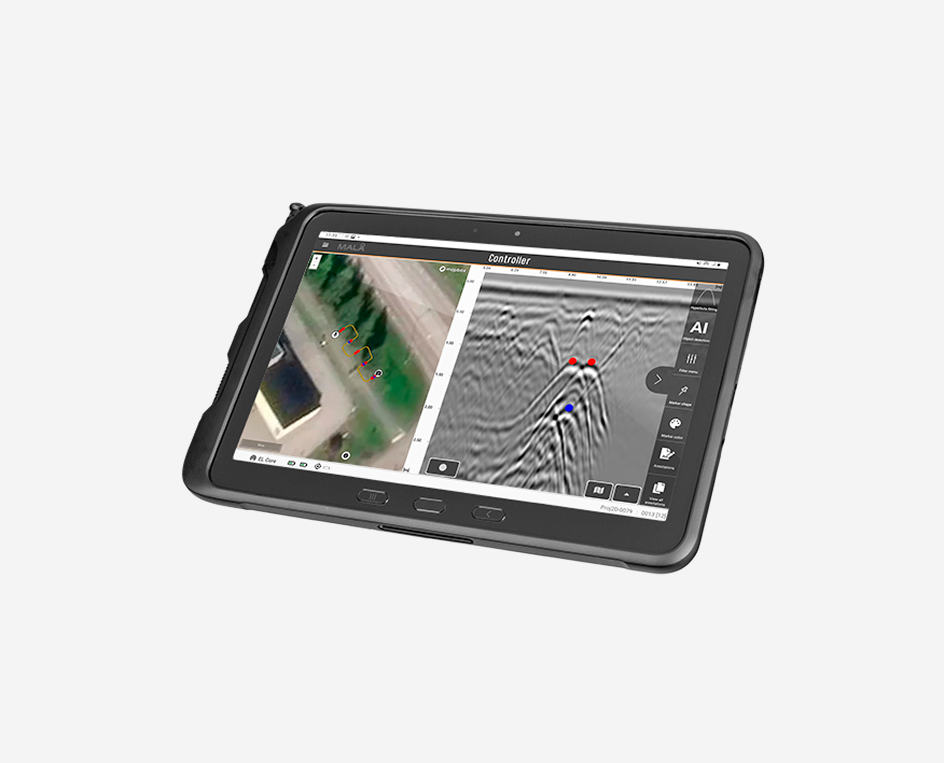
GPR measurements can also be carried out in boreholes which enables a more detailed investigation through, for example, an embankment dam. Because water content affects the radar wave velocity through a material, it is possible to present a plot of velocity variation using a colourscale to indicate areas of increase moisture/water seepage. See figure 3.
Guideline Geo provides a number of different GPR solutions for dam safety applications, visit the product pages below for more information. The processing and interpretation of the collected data can be done in different software packages, depending on application.

Figure 3. Variations in radar wave velocity between boreholes, indicating changes in water content.
Resistivity for Dam Safety Investigations
Employing resistivity for dam safety investigations can help with:
- Detection of water leaks and potential landslide areas in embankment dams
- Detection of water leaks in masonry dams.
- Long-term monitoring of water leaks
Typically, the survey is carried out on the crest or face of the dam and presented as a vertical 2D section showing the electrical properties of the dam interior.
The method can also be used to monitor changes in resistivity over time, which may be linked to development of internal erosion in the core of the embankment. Measuring changes over time can be extra valuable as water seepage may vary depending on seasons and temperature.
It is also possible to perform 2.5D or 3D measurements, but survey layout will often be constrained by the design of the dam.
The Guideline Geo Terrameter resistivity instruments cover a broad range of specifications from simple but robust units suited to VES measurements through to high performance imaging (ERT) systems. All units are also capable of recording the chargeability of the ground (how quickly voltage builds up and subsequently discharges with the application and removal of current) using time domain induced polarisation methods. This additional dataset can be very useful in the interpretation of seepage as it helps to differentiate between clay and water, for example, which have a very similar range of resistivity values.
The range of hardware options is mirrored by the choices of software which, again, range from basic, fast to learn and simple to use VES software to inversion, modelling and visualisation packages designed for advanced resistivity and IP analysis.

Streaming Potential (SP)
Streaming potential, also known as spontaneous potential or SP, is a galvanic method where the earth’s natural potential (voltage) is measured without any external energy injection. SP can be measured with all Guideline Geo’s resistivity meters. When water flows through a material with a mineral content a chemical reaction will occur causing ions to move and a potential change can be measured.
The SP method is unique among geophysical methods for embankment dams in that it offers an opportunity to detect seepage directly. If water flows through the dam a negative charge accumulation can be measured at the upstream end of a seepage flow, and a positive charge accumulation at the downstream end.
A combined interpretation based on both SP and resisitivity imaging data sets can be particularly valuable. Whilst the SP responds well to the seepage it does not deliver information on structure or saturation levels, so this is where the other results will fill in detail. The resistivity survey can provide information on both the surroudning geological setting and the internal layers and construction features of the dam plus, in some situations, estimates of porosity and pore water salinity and/or saturation.
Seismics for Dam Safety Investigations
The use of seismic methods for dam safety studies can facilitate:
- Mapping of cracks and degradation in concrete dams.
- Mapping water leaks in embankment and masonry dams
- Mapping of sinkholes and potential landslide areas in embankment dams
- Mapping of strength of masonry dams
For embankment dams the primary factors affecting the seismic wave velocity are material density, porosity and water saturation. For concrete and masonry dams, factors such as cementation, fracturing, alteration and stress generally have a greater effect on the velocity. See Fig. 4 for examples. Similar to resistivity, it is not the absolute value that is the most interesting but rather the relative change in values from the ‘background’ response seen elsewhere.
The ABEM Terraloc Pro 2 is a compact standalone seismograph, with no need for an external PC, yet it is versatile enough to cope with any seismic technique. So it can be used for refraction studies to look at the strength of materials or defects for within the dam or surrounding geology or surfae wave methods to get a quantifiable estimation of material stability and shear strength – particularly useful on embankment dams. The Terraloc can also be paired with borehole sources and sensors to take measurements within the structure itself, if necessary.
As with the other methods, there is a wide range of software options to suit the method and budget of every project.

What method and technique to use?
There are many aspects of a dam’s integrity which could be investigated, and these will normally be the primary factor in defining the methodology. Often the survey requirements will include more than one of the following targets and it may be necessary to consider a multi-method approach.
- Seepage zones. Resistivity is the primary tool, highlighting zones where increased water content has caused the ground to become more conductive. GPR can, in some situations, also indicate water but this is normally by virtue of a loss of signal due to attenuation within the more conductive, wetter deposits. A more advanced method is to analyze the radar wave velocity as this can be impacted by changes in water content.
- Structural defects. Depending on the construction of the dam, GPR is considered the primary tool, due to the excellent resolution it offers and the ability to investigate concrete elements of a dam. High frequency antennas would be suitable for investigating the integrity of surface materials and internal reinforcing materials, whilst lower frequencies can help to detect voids, slumping and cracking. Resistivity can also be useful for identifying slumping or distortion within the construction layers of the core barrier within embankment dams as well as larger voids. Seismic refraction is of limited use due to constraints on resolution, but seismic reflection can produce detailed profiles to depths unachievable with GPR, or in clay-rich environments (which can cause GPR systems to perform poorly), to look for slumping, cracking and voids.
- Slope/soil stability This is achievable with seismic methods, and it is most likely some form of surface wave measurement where shear wave velocities can be calculated. This method also allows for passive measurements which may be of interest on sites where there is a fear of damage from repeated striking of the dam when generating a seismic source.
- Monitoring of defects, i.e. repeating readings on a regular schedule to identify problematic changes in the structure can be achieved with a number of methods.