What is a Ground Penetrating Radar?
A Ground Penetrating Radar, also known as a GPR, Georadar or sometimes even Ground Probing Radar, is a non-destructive and rapid geophysical method that operates by transmitting electromagnetic waves from an antenna that reflects off subsurface layers and objects. The system collects these reflections as data, generating an image of the subsurface.
A typical ground penetrating radar system configuration consists of one or more antenna elements, a control unit, and a monitor or external Tablet/PC, for storage and display of data.

Why do I need a ground penetrating radar system?
A GPR system is an efficient tool that professionals commonly reach for when regulations or site conditions prohibit or limit digging, coring, or drilling, helping to minimize cost. Ground penetrating radar can quickly fill gaps when other methods provide only sparse, insufficient data. Our MALÅ ground penetrating radar solutions handle everything from geological surveys to utility mapping and the inspection of subsurface objects and construction interiors.
Common Application Areas where a GPR is used:
More Urban GPR Applications
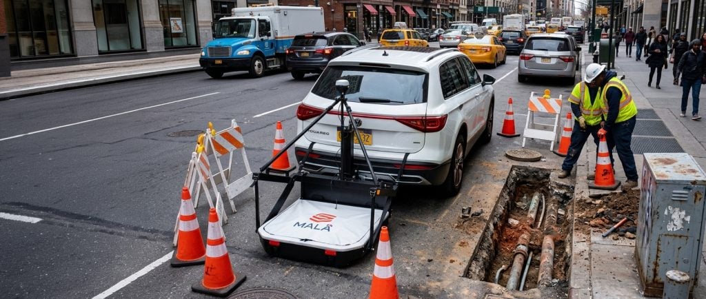
Utility Detection and Mapping
GPR locates and maps the depth of water, gas, electric, and communication lines, sanitary and storm sewers, and unknown or abandoned pipes. It also maps underground storage tanks and supports pre-studies for horizontal directional drilling (HDD). How to locate underground utilities
Concrete Investigation
GPR locates rebars and other installations within concrete and maps their depth. It also measures concrete slab thickness, detects voids, and maps concrete fractures. Read more about concrete and rebar investigations
Road and Railway Survey
GPR maps road and asphalt layering, railroad ballast, and the internal structure of roads and railways. It also supports geological investigations prior to construction, bridge deck surveys, and runway inspections at airports. Read more about road investigation
Archaeology
GPR maps archaeological landscapes, sites, features, and objects – revealing subsurface structures without disturbing the ground. Read more about GPR in archaeology
More Rural GPR Applications
Geology
GPR performs stratigraphic mapping, structure analysis, cavity and sinkhole detection, depth-to-bedrock investigations, bedrock fracture mapping, and identification of mining hazards. Learn more about bedrock mapping
Water and Bathymetry
GPR maps lakes and rivers, supports bathymetric investigations, and examines river and lake floor structures. It also assists in geological investigations for groundwater detection. Groundwater detection with GPR
Earth and Concrete Dams
GPR investigates the internal structure and layers of earth and concrete dams, detects voids, and maps concrete and rebar within dam structures. Read more about concrete and rebar investigations
Tunnels and Mining
GPR detects fractures, investigates structural integrity, and evaluates concrete thickness in tunnels and mining environments. Read more about tunnel inspection with GPR.
Environmental Surveys
GPR maps hazardous waste, underground storage tanks, and other buried utilities. It can also map bedrock surfaces to estimate groundwater flow directions and conducts lake sediment surveys. Read more about using Geophysical methods for environmental studies.
Military Applications
GPR is often used for UXO (unexploded ordnance) detection, runway integrity analysis and clearing of trenching routes etc. Read more about finding UXOs with GPR.
Ice and Snow
GPR is an excellent tool for structure analysis of ice and snow, as well as ice and snow thickness estimations and crevasse detection etc. Read more here
Ground Penetrating Radar Explained
How GPR Works
A ground penetrating radar works, in principle, similarly to a fish-finder (or echolocation device) in a boat. As the antenna moves across the surface, the transmitter radiates repetitive short-duration electromagnetic signals into the subsurface. Interfaces between materials with differing electrical properties – such as sand and bedrock, or rebar and concrete – reflect electromagnetic waves back to the receiver. These reflected traces (also called scans) form a radargram, which the system presents to the user in real-time as it collects data.
Understanding Depth and Resolution
The frequency of the transmitted electromagnetic pulse determines the depth and resolution that ground penetrating radar can achieve. A higher frequency produces higher data resolution, while a lower frequency delivers better depth penetration.
Choosing the Right Antenna Frequency
Depth and resolution requirements, combined with soil conditions at the site, primarily drive the choice of antenna frequency. The table below guides frequency selection based on the depth interval of interest. It follows recommendations from D.J. Daniels (Ground Penetrating Radar, 2004), which define the maximum penetration depth as the point at which the signal loses its full energy – typically at 20 wavelengths or less.
Note: This table serves as a guide only. Local conditions – specifically the electrical properties of the investigated media – significantly affect results at any given site. In ice and snow, for example, GPR can achieve considerably greater depth penetration.
| Antenna centre frequency (MHz) | Suitable target size (m) | Approx. max. penetration depth (m) at 100µs/m |
| 25 | 1 | 80 |
| 50 | 0.5 | 40 |
| 100 | 0.1 | 20 |
| 250 | 0.05 | 8 |
| 500 | 0.04 | 4 |
| 750 | 0.03 | 2.7 |
| 1000 | 0.025 | 2 |
HDR Technology: Better Performance at Greater Depths
To improve GPR antenna performance, Guideline Geo / MALÅ developed and patented HDR (High Dynamic Range) technology. HDR increases an antenna’s bandwidth by roughly 120% compared to a standard antenna, giving HDR-capable systems better depth penetration and resolution than a comparable non-HDR antenna.
How Depth Affects Resolution
As a rule of thumb, resolution decreases with depth. For GPR to detect an object, it must measure at least 10% of the investigation depth – meaning GPR cannot reliably detect small objects at greater depths.


Ground, Borehole, and Airborne GPR Surveys
GPR works both on the ground surface and in boreholes, with multiple antenna frequencies available for each type of investigation. GPR systems can also be mounted on, for instance, a drone for air-borne investigations.

Ground Surveys
Depending on the application and field environment, operators can pull or push GPR antennas by hand or vehicle. Choose a sled for a pull-optimized setup, or a rough terrain cart for a push-optimized system. GPR adapts to most environments, making data collection straightforward wherever the job takes you.
Borehole Surveys
For borehole investigations, operators can deploy antennas in a single borehole (single-hole measurements) or across two boreholes (cross-hole measurements).
Airborne Surveys
Teams can mount GPR systems on drones for airborne investigations, extending survey coverage to areas that are difficult or impossible to access on foot or by vehicle. MALÅ GeoDrone offers two different drount-mounted antennas for example.
GPR Considerations: Understanding the Limitations
Ground penetrating radar is a highly versatile geophysical method, capable of reaching from rebars to deep ice investigations. Like any geophysical method, however, understanding its limitations helps you get the best results. For GPR, the conductivity of the ground or construction material is the critical factor. When conductivity is too high, it efficiently absorbs the electromagnetic waves, causes energy loss, and prevents GPR from gathering useful information at depth.
When Conductivity Becomes a Problem
High conductivity can compromise GPR performance in several environments:
- Clayey and silty soils
- Salt or brackish water (groundwater, lakes, seas, or rivers)
- Areas with dissolved ions, including various types of ground contamination
- Newly laid concrete (due to dissolved ions)
- Newly salt-treated roads
Assessing GPR Suitability
A short test measurement – or prior knowledge of the site’s electrical conductivity – can quickly determine whether GPR suits the investigation or whether another method makes more sense.
As a rule of thumb, GPR performs well in any geological medium where resistivity exceeds 100 Ohm-m (conductivity below 10 mS/m). In media with resistivity below 50 Ohm-m (above 20 mS/m), GPR will in most cases prove ineffective.
GPR and Metallic Objects
GPR waves do not penetrate metallic objects. However, metal often produces a recognizable signature called “ringing,” which allows operators to distinguish metallic objects from non-metallic ones.
Related Products
Related Case Stories
- UAV- or Drone-based GPR was Successfully Used to Map Ice Thickness
- Mapping fiber optic cables with GPR
- A Comparative Study of Single Channel and Hand-Pushed Array Ground Penetrating Radar (GPR) Systems for Utility Detection
- Joining Geotechnical Investigations with Geophysical Results
- GPR Investigations at the Castle of Monteagudo
- Heat pipes and electrical wires revealed in a wooden house
- Resistivity and GPR Combination Results in Better Understanding
- High Resolution Subsurface Mapping Using MIRA HDR
- Mapping New Deposits for Increased Nickel Demand