Summary of the project
TerraSearch recently conducted a comprehensive geophysical survey of the West End Cemetery in Chester, Connecticut – a site with 272 marked graves documented in town records. The team employed multiple non-invasive subsurface imaging techniques to identify potential graveshafts and coffins, including ground-penetrating radar (GPR), terrestrial LiDAR scanning, and thermal orthoimage acquisition via uncrewed aerial vehicle flights.
Using these complementary datasets – and particularly the data generated by the MALÅ MIRA Compact multi-channel GPR – TerraSearch identified an additional 232 unmarked burials, bringing the total number of delineated burial locations to 471. The RTK-enabled, multi-channel configuration of the GPR system allowed the field crew to complete data acquisition in a single day, a task that would typically require two to three days using a conventional single-channel system.
TerraSearch also utilized the MALÅ Vision software to pick and mark individual hyperbolic reflections associated with coffins and then exported the interpreted targets into a GIS environment to produce highly accurate burial location maps for future cemetery management.
In summary, the combination of the RTK-enabled MALÅ MIRA Compact GPR and MALÅ Vision processing software produced exceptional geophysical data for the West End Cemetery and significantly improved both the efficiency and accuracy of data collection and analysis compared to traditional single-channel methods.

Final results of the geophysical survey of the West End Cemetery.
Challenges when Surveying a Cemetary
Drive by a centuries-old cemetery in the Northeast of the United States and you might assume that the headstones in view designate the precise location of each grave on the property. In fact, they might represent only a portion of the interments within the cemetery boundary and might not correlate to actual excavation sites for burial. Some markers may have fallen. Some could have been moved during cemetery beautification projects popular in the late 19th century, when cemeteries became places to visit and honor the dead. Some might have been crafted from organic matter long since decomposed. And some might never have been placed at all.
Archaeologist David Leslie, PhD., says that in cemeteries he surveys around the country the ratio of marked to unmarked graves is often 1:1. His firm, TerraSearch Geophysical, regularly works with municipalities and historical societies to conduct surveys of active and inactive cemeteries and produce more accurate assessments of the number and location of grave shafts on the property.
The firm uses non-invasive techniques to protect sites with cultural and historical significance and works as efficiently as possible to accommodate limited budgets. In the case of a recent project at West End Cemetery, a cemetery established in 1813 in Chester, CT., the goal was to identify all marked and unmarked burials within the cemetery boundary and document grave markers and associated cemetery elements.
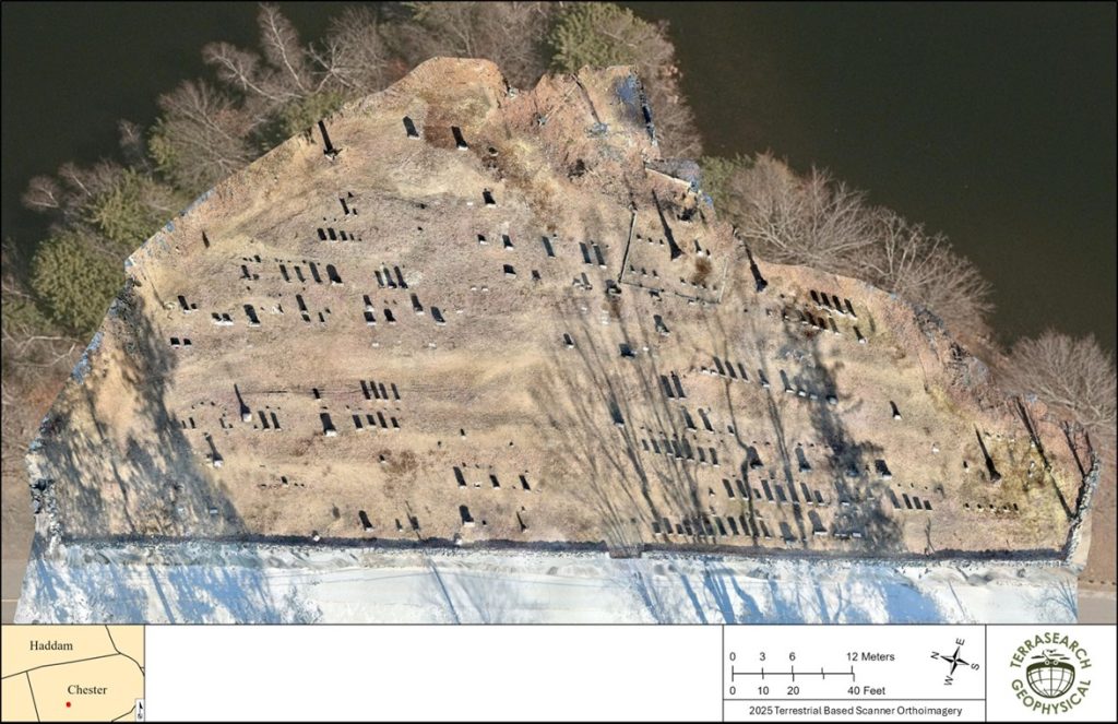
High resolution orthomosaic image of the West End Cemetery, created from a terrestrial LiDAR and photogrammetric survey.
Solution: Integrated GPR, LiDAR, and UAV Thermal Imaging for Cemetery Analysis
To accomplish their task, Dr. Leslie and his team began with thorough background research and a detailed review of primary and secondary sources, maps and aerial photographs. They then used a suite of non-invasive geophysical methods to survey the site.
For the GPR survey, the team used Guideline Geo’s MALÅ 3D Imaging Radar Array (MIRA) Compact. The antenna includes 10 separate 500 MHz single channels housed within the array and spaced at 6.5 cm (2.6 in) providing an individual data-collection width of 60 cm (23.6 in). The team mounted a laptop on a custom-built MALÅ carriage and used an encoder-triggered collection of 50 traces per meter (one reading every 2 cm or 0.8 in). Because the 10 channels are aligned in an array, it wasn’t necessary to consider from which direction the GPR would intercept targets; the data collection provided true three-dimensional data sets. The GPR data were encoded with RTK NTRIP corrected GPS data, providing centimeter-accurate positional data for each individual GPR trace and profile collected.
Had the team used single-antenna GPR, Dr. Leslie estimates the survey would have taken two or three days. With the MIRA, the team had their GPR data in about six hours. According to Dr. Leslie, the MIRA Compact is often ideal for this work because it highlights features produced by dielectric contrasts between fill and surrounding sediment, truncation of internal stratigraphic layers, and high-amplitude reflections from bricks or stones.

GPR amplitude map of the West End Cemetery in Chester, Connecticut, displayed at approximately 50 cm beneath the ground surface. Coffins and a (buried) gravel road are indicated by darker color (black) high amplitude reflections.
With GPR data in hand, he used MALÅ Vision software to pick and mark each individual hyperbola associated with a coffin and export them into his GIS system to develop exceptionally accurate maps for existing grave locations.
“I like the quality of the MIRA and the fact the Guideline Geo has been around for a long time,” says Dr. Leslie. “And the MALÅ Vision software is a really easy and effective way to interpret the data.”

Example of identified and marked hyperbolas. The radargrams are identical and show before (lower left) and after (lower right) the picking of identified hyperbolas. The position of the radargrams is indicated by the white arrow in the amplitude map (above).
In addition to using GPR, the team also conducted a low-flying thermal UAV survey and terrestrial-based LiDAR and photogrammetric survey of the site and created a georeferenced orthomosaic with the imagery. From there, they were able to develop three-dimensional models of select memorial stones or headstones using digital photogrammetry techniques from photographs taken of each stone during field data collection.
Finally, Dr. Leslie reviewed the GPR, background, and imagery data to systematically assess the survey area for soil anomalies and make informed decisions about their nature (i.e., grave shafts, landscaping, utilities, etc.). He then produced a comprehensive technical report, complete with detailed summaries of all facets of the team’s research, methodology, survey results and recommendations.
Conclusions of the study
The West End Cemetery, actively in use today, had records indicating 272 interments on site. However, TerraSearch’s survey revealed that there were actually 471 burials in the cemetery: 232 probable unmarked burials, including six probable cremation urns, 192 marked burials with clear geophysical evidence, and 47 marked burials that did not correspond to any geophysical indicators of a grave.
With this information, the town of Chester can update the plot boundary, conduct affairs with a better understanding of the cemetery’s capacity, and perhaps learn more about the unnamed buried there.
Related Instruments and Software from Guideline Geo:
Related Geophysical Method:
Acknowledgement
We would like to thank TerraSearch Geophysical https://terrasearchgeo.com/ for sharing this case. You can also follow them on Linkedin: https://www.linkedin.com/company/terrasearch-geophysical/.


