Unmatched Mobility: Geophysical Surveying for Any Terrain
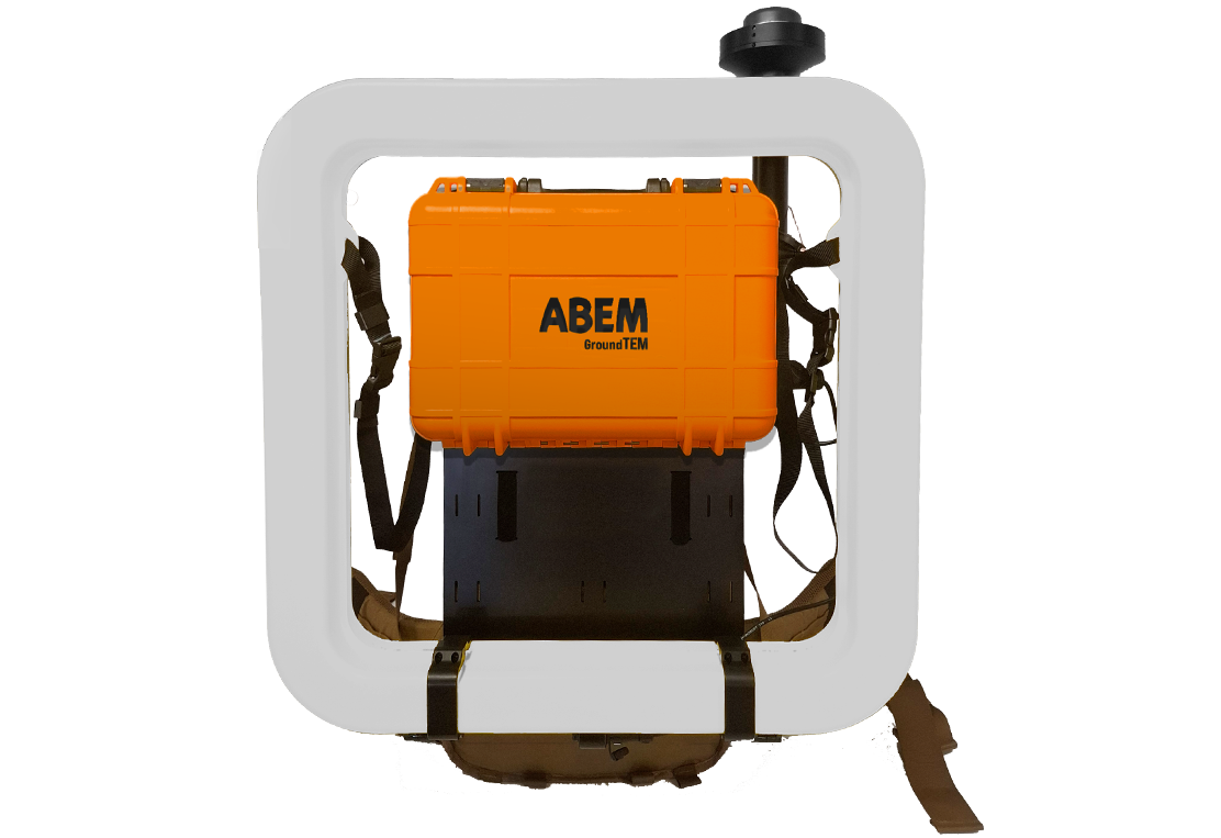
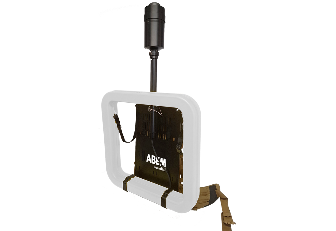
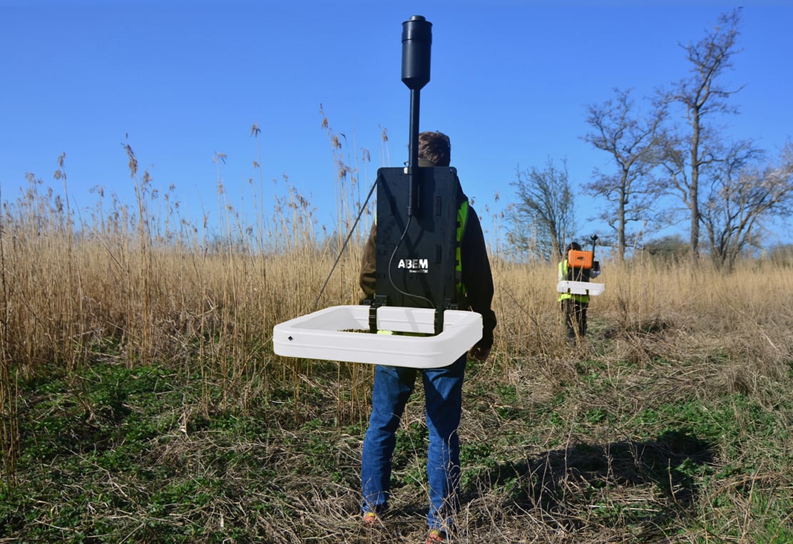
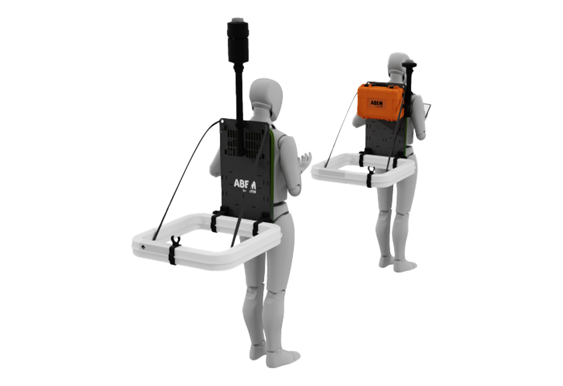
ABEM GroundTEM Trek maps subsurface geology for applications in hydrogeology, geotechnical surveys, and mining. Its lightweight backpack-mounted transmitter and receiver allow efficient surveying even in remote terrain.
With a depth range of 50–100 m, the system records continuous data with GNSS and altitude tracking. When Premium features are enabled, real-time processing and inversion reveal geological structures instantly in the companion mobile app.
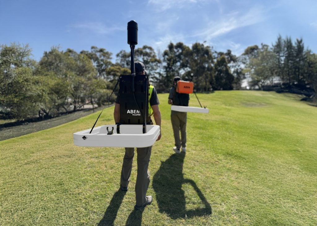
Take your exploration where vehicles can’t go. The ABEM GroundTEM Trek is a professional, backpack-mounted TEM-system designed for true mobility. Split into lightweight transmitter and receiver modules (approx. 12-15 kg each), the system allows you to collect continuous data simply by walking. Whether you are navigating steep hills, forestry, or uneven construction sites. If you can hike it? You can map it. The wireless design eliminates cumbersome cables, ensuring a safer and faster workflow in even the most challenging terrain.
Versatile Applications: From Groundwater Mapping to Finding Minerals
Designed for versatility, the ABEM GroundTEM Trek is the ideal solution for a wide range of near-surface investigations. Its non-invasive technology is perfect for groundwater exploration, helping to pinpoint aquifers and avoid saline intrusion. For the mining sector, it provides critical data on depth-to-bedrock, clay layers, and potential underground barriers. By revealing subsurface risks before you break ground, the Trek helps minimize project delays and optimize drill siting.
Groundwater
A high sensitivity to conductive materials makes TEM extremely useful in groundwater studies, for example differentiating between fresh, brackish and saline deposits, monitoring drawdown and recharge of an aquifer, or simply estimating its extents by building up profiles or grids of soundings.
Environmental
TEM provides a rapid means of surveying for a range of environmental applications from identifying potentially hazardous clay units within a geological sequence, to mapping and monitoring dynamic features such as permafrost thickness or pollution plumes.
Minerals
TEM responds well to conductive mineral bodies. The ABEM TEM line-up provides powerful tools in the search for new mineral deposits with options for rapid coverage using semi-mobile and mobile systems, and deep surveys with systems offering high output currents.
Features
Comprehensive Coverage
Conduct surveys along lines or 3D, covering entire landscapes with depths ranging from a meter to 100 m.
Superior Data Quality
Advanced electronics and robust design ensure reliable and accurate measurements, even in challenging field conditions.
High Efficiency
With the backpack-mounted carrying system you can make larger surveys faster and more efficient than with a static system.
GroundTEM Trek app
Alongside the hardware, there is a software requirement for controlling the instrument. The GroundTEM Trek App is necessary for:
- Configuring the instrument
- Collecting data
- Reviewing data
- Visualizing maps and drawings
- Navigation
It has a basic GIS-type presentation where multiple maps, figures and drawings can be uploaded and overlaid onto each other with or without transparency. The software paints a swath behind the system as data is collected (below left).
GroundTEM Trek App
Alongside the hardware, there is a software requirement for controlling the instrument. The GroundTEM Trek App is necessary for:
- Configuring the instrument
- Collecting data
- Reviewing data
- Visualizing maps and drawings
- Navigation
It has a basic GIS-type presentation where multiple maps, figures and drawings can be uploaded and overlaid onto each other with or without transparency.

The software paints a swath behind the system as data is collected.

Real-time processing of data – to produce an interpretable resistivity model in the field, instead of only looking at raw data – is available as a premium subscription feature.
The GroundTEM Trek App is designed primarily to run on Android phones and will be available through the Guideline Geo Google Play store prior to the first delivery of customer instruments. An APK will also be available via the Guideline Geo website.
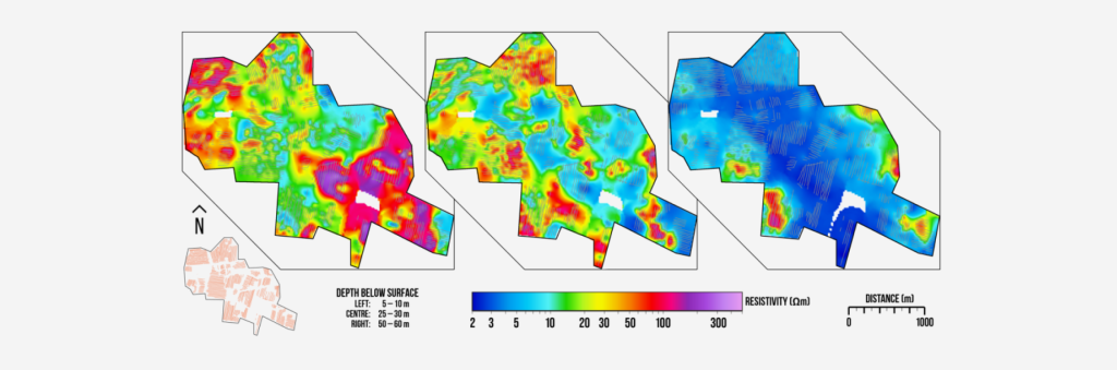
Instant Insights: Real-Time Data to 100 Meters Depth
The very portable GroundTEM Trek efficiently surveys anything from a single profile to large areas, providing detailed subsurface images, even in remote and rugged landscapes.
Don’t wait until you are back in the office to see what lies beneath. The ABEM GroundTEM Trek delivers high-resolution Transient Electromagnetic (TEM) data from the surface down to 100 meters (328 ft). Controlled entirely via a user-friendly Android app, the system offers real-time data processing and inverted models directly on your screen. This immediate feedback allows field teams to make on-the-spot decisions, quality-check results instantly, and adjust survey lines dynamically to capture the best possible data.

Frequently Asked Questions (FAQ) about the GroundTEM Trek
How much data can you collect in a day with the GroundTEM Trek?
Well, how fast can you walk? Over reasonable terrain, 3-4 km per hour is achievable.
As a wireless system, how do you keep the distance between operatives correct?
The lead operator has a distance gauge in the GroundTEM Trek App. The rear backpack provides an audio alert when approaching the distance limits.
What is the maximum achievable depth with a GroundTEM Trek?
The maximum is between 50 m and 100 m, but this is highly dependent on geology. If survey targets regularly exceed 75 m depth, consider an alternative solution such as the GroundTEM i-Series with Explorer Coils, the GroundTEM Ralli, WalkTEM 2, or a Terrameter LS 2.
GroundTEM Trek app
Alongside the hardware, there is a software requirement for controlling the instrument. The GroundTEM Trek App is necessary for:
- Configuring the instrument
- Collecting data
- Reviewing data
- Visualizing maps and drawings
- Navigation
It has a basic GIS-type presentation where multiple maps, figures and drawings can be uploaded and overlaid onto each other with or without transparency. The software paints a swath behind the system as data is collected (below left).
Selected Technical Specification
General
| GroundTEM Trek Software | Navigation, data collection, and visualization |
| Power | 14.4 V (Tx) 10.8 V (Rx) |
| Speed | How fast are you on foot? |
| Environment | -20 to +50 °C |
Transmitter
| Output current | Dual-moment 1 A / 10 A |
| Tx coil | 0.65 × 0.65 m, 4-turn |
| GNSS | Onboard (SBAS corrected) |
Receiver
| Channels | 1 |
| Rx coil | 0.65 x 0.65 m, 53-turn |
| First-/ Last Gate | 5.5 – 350 µs |
| GNSS | Onboard (SBAS corrected) |
| Rx/Tx coil separation | Monitored by UWB ranging |